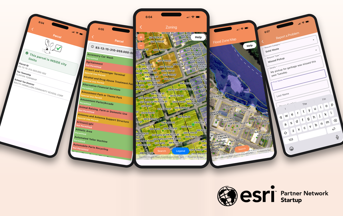
Mobile app turns local GIS data into simple, single-question maps that cut down on phone calls to city and county offices
BILLINGS, MT, UNITED STATES, October 22, 2026 /EINPresswire.com/ — Katalog, a company that has developed a mobile app that gives residents easy access to their local government’s mapping data, today announced its acceptance into the Esri Partner Network (EPN) under the Startup Program as a startup partner. The program supports a competitive application process and is part of an Esri initiative to help startups succeed with Esri’s ArcGIS technology and scale location intelligence into their geospatial-enabled offerings, while fostering a longstanding partnership within EPN.
Katalog connects to data that many local governments already maintain within Esri, such as addresses, parcels, and zoning districts, and presents it as simple maps powered by ArcGIS location services. Each map in the app is built to answer a specific question and can be explained in a “how-to” of just a few sentences. Residents can check what uses are permitted on a parcel, find their ward or polling place, see whether an address is inside city limits, or look up flood zones, all in a few taps and without calling the office.
“From my experience working in local government, I know city and county staff answer many of the same questions every day: What’s my zoning? Where do I vote? Is this inside city limits?” said Steve Gilbert, founder of Katalog. “Joining the Esri Startup Program and partnering with Esri through the Partner Network lets us build on a leading GIS platform that so many cities and counties already use, while providing their residents with a simple location-enabled visual interface to get answers.”
Providing end users with an affordable, focused, use-case-driven GIS solution that supports a specific business challenge for local governments is a key part of the company’s mission. “Many small towns and counties, who are constantly forced to tell their staff to do more with less, don’t have the budget to adopt and implement the latest technology,” said Gilbert. “We priced Katalog so that for a smaller community, a year of service costs less than 10 hours of consultant work.”
How it works
Cities and counties that subscribe appear in Katalog’s app, and residents tap on their location to see the maps that jurisdiction has set up. Setup involves configuring a few tables, and the more layers a government configures, the more maps its residents can use. For governments that use Esri, Katalog can connect to Citizen Problem Reporter, an ArcGIS-based solution that lets the public submit and track 24/7 non-emergency community issues, so residents can report public works and other concerns from the app.
About Katalog
Katalog is a mapping software company focused on the needs of local government clients that bills itself as “Just north of magical.” Headquartered in Billings, MT, Katalog strives to empower citizens by making data easily accessible, including those who don’t consider themselves to be “tech” people. To learn more or request a demo, visit katalogmaps.com.
Steve Gilbert
Katalog
+1 281-435-0832
steve@katalogmaps.com
Visit us on social media:
LinkedIn
Legal Disclaimer:
EIN Presswire provides this news content “as is” without warranty of any kind. We do not accept any responsibility or liability
for the accuracy, content, images, videos, licenses, completeness, legality, or reliability of the information contained in this
article. If you have any complaints or copyright issues related to this article, kindly contact the author above.

Media gallery